The early years
At the time of the Roman invasion of Britain in AD 43, the place now called South Shields was in part of the territory of the British tribe of the Brigantes.

The area under the control of this tribe was large and there may have been various sub-kingdoms within it, but in overall charge was Queen Cartimandua and King Venutius. The Romans came to an agreement with Cartimandua that left the Brigantes a political ally of the Romans for many years. Cartimandua supported the Romans – even handing back a British king fighting the invaders who came to her seeking sanctuary – and the Romans helped Cartimandua in her internal fights maintaining control of the Brigantes.

In about AD 69, however, King Venutius gained control of the Brigantes and within a few years the Romans decided it was time to expand their territory and bring northern Britain into the Empire, some 26 years after they first invaded southern Britain. The Romans pushed north rapidly and by AD 77 the kingdom of the Brigantes was conquered. The Roman tried to take territory further north, but by AD 87 they gave up on this idea and consolidated their gains.
It is likely that it was during the 80s that the first fort was built at South Shields, when the Romans were still pacifying the newly conquered territories. They chose a spot on the hill near the mouth of the Tyne (now called the Lawe), which excavations have shown was covered in cultivated fields at the time. The Romans cleared away the local farmstead(s) and displaced the British families, who may have lived there for generations, to get the land they required. The fort, built of timber and turf, was only one part of the settlement: there was a bath-house for the soldiers, a civilian settlement for traders, a training ground for the soldiers, fields to hold their cattle and pastures for their cavalry horses, and a cemetery for the dead.
Although the exact location of this fort is unknown, pottery and brooches dating to this period show it must have existed.
The coming of Hadrian’s Wall
Forty years or so after the timber fort was built, work started on building Hadrian’s Wall north of the river (about AD 122). The Wall started at a river crossing at a spot where Newcastle and Gateshead would later be built, and was then extended to a bend in the river at the point now known as Wallsend. From here to the coast the River Tyne was used as the frontier barrier. Although not joined to Hadrian’s Wall, the fort at South Shields was part of the whole frontier zone.

The building of the Wall would have involved more sea traffic, bringing in troops and supplies, and perhaps therefore more traders also, and the civilian settlement (vicus) round the timber fort expanded. Traces of some of the buildings and roads have been found under the later stone fort.
Sometime in the period AD 130 – 150 the timber fort reached the end of its life. There may have been a major rebuilding on the same site, but it is also possible the new fort was built in a slightly different location, as the new buildings in the vicus were built on a slightly different alignment to the earlier structures. A large training ground, flat and well-drained, was also built at this period.
In AD 142 Emperor Antoninus Pius moved the frontier in Britain much further north, and marked it with another Wall (the Antonine Wall).


South Shields was now far behind the frontier zone and the fort may have been moth-balled as surplus to requirements, although its position near the coast and river may have meant it remained in use to guard the supply routes down the river. This new northern frontier only lasted for 20 years, before the border moved back to the line of Hadrian’s Wall.
It is likely that the tombstones of Victor and Regina, two of the best Romano-British tombstones in the country, date to this phase of occupation. Both stones reflect the multi-cultural mix of the Roman empire. Victor was a Moor from north Africa, and was the ex-slave of a cavalry soldier, Numerianus, from Spain.

To the spirits of the departed (and) of Victor, a Moorish tribesman, aged 20, freedman of Numerianus, trooper of the First Cavalry Regiment of Asturians, who most devotedly conducted him to the tomb.
Regina was from the tribe of the Catuvellauni in southern England and was the ex-slave of Barates, from Palmyra in Syria.

To the spirits of the departed (and to) Regina, his freedwoman and wife, a Catuvellaunian by tribe, aged 30, Barates of Palmyra (set this up).

Both stones are also a reminder of how pervasive slavery was in the Roman world.
The stone fort
With the frontier back at the River Tyne in the 160s, a decision was made to build a new fort at South Shields, this time built out of stone. The chosen location was a spot which overlooked both river and sea. This area was already occupied by buildings in the civilian settlement belonging to the timber fort, but these were all demolished and cleared away.
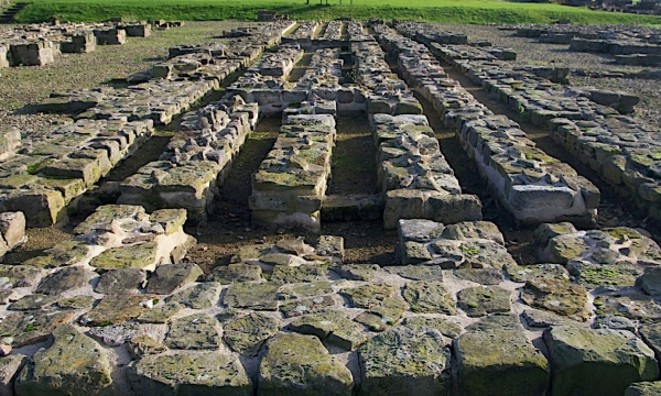
This fort, built about AD 163, was a typical auxiliary fort intended for a mixed infantry and cavalry unit called a cohort (cohors). It housed about 480 infantry soldiers in six barracks and 120 cavalry soldiers in four barracks.
There was also a central range of buildings consisting of a double granary, a headquarters building (the most important building in the fort) and the commanding officer’s house.
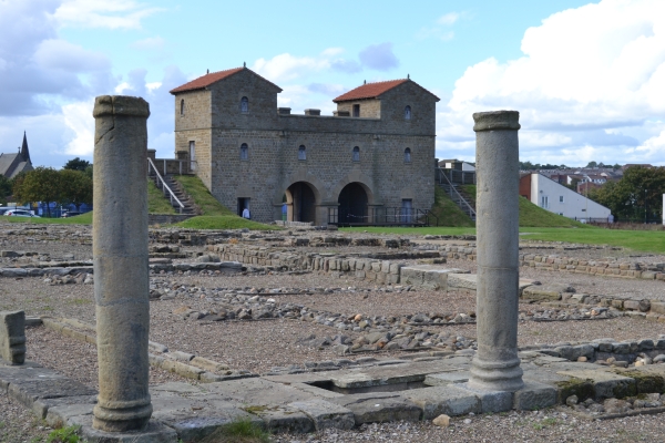

The reconstructed gateway at the site represents a building of this period.

As usual with Roman forts there was also occupation outside it, which would have occupied more territory than the fort itself. There was the civilian settlement (part of that to the west of the fort has been excavated), a bath-house (location unknown), a cemetery (lining the road leading away from the fort to the south-west), and a temple (near the Beacon).
The supply base
The stone fort was in use for about 40 years. Then Emperor Septimius Severus decided to try to conquer more land to the north, and the decision was taken to convert the fort at South Shields into a supply base to store food for the armies in the field. This use as a supply base is what makes South Shields fort unique.

The conversion was a major piece of work. The fort had to be expanded to the south to provide accommodation for the troops, while the existing buildings were demolished to make way for granaries to hold the grain and other foodstuffs. The original plan was probably for the supply base to take up half of the expanded fort, but in the end it took up about two-thirds, leaving only a small area for the soldiers. Even the headquarters building in the centre of the fort was converted into two granaries, while a much smaller headquarters was built in the south part of the fort to replace it. At its greatest extent there were 24 granaries in the supply base, equivalent to the food supply for 12 forts.
Septimius Severus came to Britain with his two sons, and co-Emperors, Geta and Caracalla.


Evidence from finds at the fort, including the largest collection of Imperial lead sealings (used on baggage and similar items) found in Britain, suggest that the Imperial household visited South Shields at some point.

In AD 211 Septimius Severus died in York, and the wars to the north were quickly concluded so his sons could return to Rome. The fort, however, remained a supply base, probably now supplying forts along Hadrian’s Wall.
An altar from this period, recording the safe return of Caracalla and Geta to Rome, records the probable name of the fort at this time as Lugudunum.

To the gods the Preservers for the welfare of the Emperor Caesar Marcus Aurelius Antoninus Augustus, Most Great Conqueror of Britain, [and of the Emperor Caesar Publius Septimius Geta Augustus, conqueror of Britain], the military unit at Lugudunum paid its vow for their safe return.
The name of the unit who garrisoned the supply base period was the Fifth Cohort of Gauls (cohors V Gallorum) from France.

The Emperor Caesar Marcus Aurelius Severus Alexander Pius Felix Augustus, grandson of the deified Severus, son of Antoninus the Great, pontifex maximus, with tribunician power, father of his country, consul, brought in this supply of water for the use of the soldiers of the Fifth Cohort of Gauls, under the charge of Marius Valerianus, his propraetorian legate.

One of the infantry barracks they occupied in this period has been reconstructed on the site.

The fire
The supply base operated for about 70 to 100 years. Then in the late third or very early fourth century there was a large fire that destroyed many of the buildings in the southern end of the fort. Excavations revealed a thick layer of burnt material, which included a ringmail suit of armour that had not been rescued from the fire. This is the most complete and best preserved ringmail suit from Roman Britain.

The decision was taken to rebuild the fort in a modern style of fort design, with the headquarters building set to one end of the fort rather than in the centre. The fort was divided in half, and the northern end remained a supply base. The other half, for the accommodation of the troops, was divided into four quarters, with some of the old granaries expanded and converted into barracks. The small headquarters was demolished, and the original headquarters was brought back into use, although now it was facing to the south, rather than the north, and situated at the end of a long processional road leading up from the south gate.
A late Roman document suggests the name of the fort at this period was Arbeia, thought to mean ‘place of the Arabs’.

This may be because the unit who garrisoned the rebuilt fort, mentioned in the same document, was the Unit of Tigris Boatmen (numerus Barcariorem Tigrisiensium), from an area in modern Iraq. The Boatmen may have been stationed here because of an increased threat from pirates along the coast in the late Roman period.
The reconstructed commanding officer’s house at the site is based on the building from this period.

The end of Roman occupation
The rebuilt fort was in use for about 100 years, with occupation lasting into the early fifth century. The late fourth century was a period of political upheaval and by AD 410 Britain was no longer supported from abroad, having been told to look to its own defence. This may have been intended to be a temporary measure, but it ended being permanent and Britain was never again seen as part of the Empire. It is unclear what happened to the garrison at South Shields, and how long the fort continued to be occupied by a military force, although repair work on some of the buildings continued into the fifth century. The end of occupation was likely to have been long drawn out and gradual, but at some point the last occupants accepted that living in a settlement designed for hundreds of soldiers, with a fort full of old and empty store buildings, all requiring lots of maintenance, was no longer viable and/or desirable, and abandoned the fort. Over the years storm damage, rotting timbers and the lack of maintenance would have led to the buildings collapsing – the Victorian excavations uncovered one wall of the headquarters that had fallen down flat – and then the site was used as a quarry for conveniently ready-cut building stones, which were taken away to be used elsewhere.
After the Romans
There is evidence for some use of the land in the early medieval (Anglo-Saxon) period, but after that the site became farmland and remained farmland until 1875. Most of the Lawe, including the area of the fort, was in the township of Westoe (which only became part of South Shields in 1850) and was owned by the Dean and Chapter of Durham Cathedral. The land was finally sold in 1875 in order that houses could be built on it, allowing South Shields, so far mainly restricted to the river’s edge, to finally expand to the east.
This building work led to some local antiquarians arranging for the excavation of the Roman remains to be carried out before the land was built over. Public interest meant that part of the remains were taken into Council care, one of the earliest examples of this happening, and a Roman Remains Park was established.

Over the years clearance of most of the Victorian buildings over the fort has enlarged the park grounds to the site as it is today.
Romans elsewhere in South Shields
The Roman settlement in South Shields is mainly on the Lawe. However, there were roads running to and from the fort, and somewhere along the river (probably now lost under later ballast hills) would have been the port that made South Shields the perfect place for a supply base. There is one known Roman shipwreck in the river-mouth, but there will be many more out there. Outside the immediate area of the fort there would be native British farmsteads, although sadly very few of these have been found and excavated.
Written by: Alex Croom, Keeper of Archaeology, Arbeia, South Shields Roman Fort
Photos:
Terry Ford
Wikipedia