Harry Houdini escaped from South Shields nick?

In 1904 Harry Houdini was appearing at the Empire Palace in South Shields and part of his publicity campaign was to escape from the local nick (prison).
READ ALL ABOUT IT!

THE SHIELDS DAILY GAZETTE AND SHIPPING TELEGRAPH, WEDNESDAY, FEBRUARY 10TH, 1904
HOUDINI’S ESCAPADE.
BREAKING OUT OF SOUTH SHIELDS CELLS
EXTRAORDINARY FEATS.
Harry Houdini, famous all the world over as a prison breaker and handcuff expert, and who is now appearing at the Empire Theatre, South Shields, was, yesterday, given an opportunity of showing his skill in the police cells of the South Shields Central. A number of members of the Watch Committee and a few privileged friends were present when Houdini “gave himself up” to Supt. Cowe. He was marched forthwith to cell in the corridor, where was stripped to nudity. He was then brought back to the corridor, and in the presence of the Chief Constable, Mr. Wm. Scott, and the company present, his wrists were bound by the police with three police handcuffs, one the regulation handcuff, the second American patent “bracelet,” and the third a cuff known as the “Figure of Eight.”
The cell in which his clothes were left was locked with a triple lock. Houdini was put into another cell and triple lock was also turned upon him. At the artiste’s request the whole of the cells were inspected beforehand. The inside the cell door, by the way, is sheeted with quarter inch iron plate, which is bolted down, and as there is absolutely no access the lock from the inside, the trap door, through which the prisoner’s fare passes and which enabled Houdini to reach the lock outside from his place of confinement, was allowed to remain down. “I don’t say I’ll do it, but I’ll try,” was the facetious remark with which Houdini parted with the spectators, who then retired outside the iron gate, which was also locked. They had not long wait for developments. The sound of the falling steel cuffs were first heard, then the noise a tampering with the cell’s lock. In a twinkling almost Houdini released himself. In quicker time than it takes to tell it he opened the cell in which his clothes were locked, and emerging a few moments almost fully dressed he tripped up to the iron gates through which the astonished crowd were peering, burst open the last exit and declared himself a free man. The smart manipulation of the locks and the ease with which they yielded to him, was extraordinary, the whole adventure being over in five minutes.
Houdini afterwards referred to the cells of the South Shields Station as being exceptionally good and strong. This is something like the 62nd escape Houdini has made from cells in various parts of the country. Houdini is an American, having been born at Appleton Wisconsin. One of his most marvellous feats was an escape from the Siberian transportation cell or larette in Moscow. Although heavily chained and handcuffed he had gained his freedom in twenty minutes.
The event was so successful it was used as part of publicity campaign for that well known ointment called Zam-Buk.

Sources:
British Newspaper Archives
That the North Sea was called the German Ocean?
In South Shields in the 19th century people would generally talk about the “North Sea” but many maps until the late 19th century would refer to the “German Ocean” or “German Sea”. These names come from the Latin names “Mare Germanicum” and “Oceanus Germanicus”. Latin was the language of international communication until well into the 18th century, but map makers carried on the Latin tradition longer than others. The First World War ended most references to the “German Ocean” or “German Sea” on maps.

That Ocean Road was called German Street?
The road leading from Fowler Street to the sea was known as German Street until the 1860s. It was named German Street because it led to the German Ocean. German Street in the early 1800s was just a dirt track but after a new road was built in 1860 it needed a new name and German Street became Ocean Road.

Some people still called it German Street until about 1870 but use of the term is rare after that, and its use ceased well before the First World War.

That a Native American of the Sioux Nation is buried in Harton Cemetery?
Alfred Orlando Taylor was born about 1834 in Buffalo, America and was a member of the Sioux Nation. He probably came to England in the 1870s as a seaman. In 1881 he was living in Norfolk with his partner Martha Mingay, a widow. He had 5 children with her. By 1891 he was living in Jarrow and working as a shipyard labourer and then in 1901 living and working in Hebburn as a plater’s labourer in a shipyard. In the 1911 Census he was living in Hebburn and was described as a general labourer aged 78 (though presumably no longer working?). He later was admitted to South Shields Workhouse at Harton where he died on the 18th April 1923, of senility. He is buried in Harton Cemetery.

That the Lawe Top was once an Island?
There are several sources of information confirming that the Lawe Top was indeed an island!
The first is a map dated 1787 which shows the River Branin running from the Mill Dam almost to the sea.

The next is an account of 1890 which refers to a “large vessel” found in this channel which suggest the river had originally been much larger and navigable.
South Shields particularly is no longer anything like what Nature made it. Even considerably less than a hundred years since, it was still a sort of quiet rural place. The high and low ends of the town were originally connected by a bridge thrown across a wide stream, which covered what is now called the Mill Dam. This splendid natural dock was the remains of an old sanded-up arm of the river that had once disembogued itself into the sea about half-way between the end of the Herd Sand and the Trow Rocks. The remains of a large vessel were found at a considerable depth, some years ago, in this old channel, embedded in sea sand mixed with shells. Some have conjectured, from the width of the valley and other indications, that this may in former times have been the main channel, or at least a large navigable mouth, so that the eminence at the Lawe, upon which the old Roman fort stood, was originally an island, first connected with the mainland by a long embankment, or causeway, in continuation of the Military Way, or Reken Dyke, literally the Giants’ Dyke.
Eighty or ninety years ago, the Mill Dam, when filled with water from the river at high tide, was a very pretty object, its sides being covered with bright green salt grass, with gardens sloping down to it. It figures in old maps as a large ham-shaped basin, with the shank to the west, spanned by a bridge, and extending fully as far east as Waterloo Vale. But in the years 1816-18 shortly after the general peace, and during the currency panic, the trade of the town being in a deplorable state, and a number of workmen, especially shipwrights, being thrown idle, the men were employed in filling up the Mill Dam with ballast from a large heap which occupied the site of the present road past the glass-works—then Cookson’s, afterwards Swinburne’s, now Palmer’s—and extended as far east as the end of West Street or Joe Lee’s Lane on the one hand, and westward to the Mill Dam Bridge on the other.
The next is G. B. Hodgson’s 1903 account:
There is reason to believe that the Tyne at one time entered the sea by three mouths: the first, or southern channel, diverging from the main stream at the creek now known as the Mill Dam, and following the depression still plainly traceable to the south of St. Hild’s Church, and seaward through Waterloo Vale, debouching into the ocean about where the road between the Marine Parks now runs; the second, the present channel through the Narrows; and the third following the depression between Tynemouth and Collingwood’s monument, discharging at Prior’s Haven. Upon this theory the ancient Lawe—that portion of the modern town roughly represented by the Shields and Beacon Wards of the Municipal Borough—would originally be an island, separated from the mainland by the more southerly of the three channels. The oldest existing map of the district, of the time of Henry VIII preserved among the Cottonian MSS in the British Museum, shows this channel with a triangular-shaped island between it and the main stream, and although the island is shown too far to the north and west on the map, it probably represents what is now Shields Heugh. Confirmatory evidence of this theory was unearthed little over sixty years ago in the shape of the blackened remains of a large vessel, which were found at considerable depth in this old channel, embedded in sea sand mixed with shells. The eastward end of this channel appears to have been gradually choked and converted into a morass, but in Fryer’s map, published only a century and a quarter ago (1773), the tide is shown as flowing up the gut from the Mill Dam as high as the Sunderland Road, as it was then called, now Fowler Street.
Hodgson then goes on to say the River Branin “flowed as far as modern Catherine Street” which is roughly where the old library was:

So, this all points to the fact that the Lawe was indeed an island which would have strengthened its importance as a fortress for both the Brigantes and the Romans. Once the Mill Dam was built in the 1600s this would have reduced the River Branin’s flow and when it was filled in during the years 1816-18 the Lawe Top would have ceased to be an island!
So really people on the Lawe Top should be called “SkytIslanders” not “SkytEnders”!
Sources:
G. B. Hodgson, Borough of South Shields, page 2 and page 121
Les Snaith
Mick Ray
Monthly Chronicle of Lore, Newcastle, 1890, page 277
That it was once possible to walk across the River Tyne?
Fancy taking a walk across the River Tyne from about the end of the Groyne over to Tynemouth? Well that is what a few people have done on 3 occasions in the early nineteenth century!
Walk one was on Thursday 26th August 1824 when three pilots walked across the “Tynemouth Bar” from South Shields to North Shields on what was reported to be “the lowest spring ebb ever”.


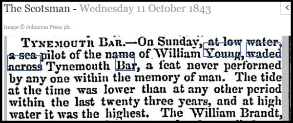
Walk two was on Sunday 8th October 1843
Walk three was on Sunday 6th September 1846

There are several things to notice in these reports: one the tides were exceptionally low, two all these walkers were pilots who would know the river like the back of their hand, three it was only ever done in one place, the Tynemouth Bar. So a stroll across the Tyne was only ever done with exceptional tides, people and place it was far from a common event.
Why was the river so shallow? Well, thanks to inaction by the City of Newcastle the river was not dredged in those days, it was full of sandbanks and a lot of ballast was deposited in the river.
A river mouth bar is an elevated region of sediment typically found at the mouth of a river where the river flows out to the sea. Sediment is transported by the river and deposited, mid channel, at the mouth of the river. This occurs because, as the river widens at the mouth, the flow slows, and sediment settles out and is deposited.
The 1787 map shows the depth of water at the “Tynemouth Bar” as 8 feet so a drop of water down to two feet as mentioned would be quite feasible.

Obviously the addition of the two piers and over 150 years of dredging make such a “plodge” impossible now.
Sources:
British Newspaper Archives
Les Snaith former Royal Navy Lieutenant Commander
Johnny Cash performed in South Shields?
Yes the “Man in Black” on September 1st 1987 appeared on stage at the Bents Park as part of the All American Mardi Gras Festival with his wife June Carter.


Johnny Cash (1932 to 2003) was one of the best-selling music artists of all time, having sold more than 90 million records worldwide. Albert and Pat Tate were Mayor and Mayoress at the time this photo was taken.

Set List
1. Ring of Fire
2. Folsom Prison Blues
3. Sunday Mornin’ Comin’ Down
4. Peace in the Valley
5. Highwayman
6. One Piece at a Time
7. Let Him Roll
8. Committed to Parkview
9. Big River
10. I Still Miss Someone
11. The Wall
12. Long Black Veil
13. Get Rhythm
14. I Got Stripes
15. (Ghost) Riders in the Sky
16. Jackson
17. Where Did We Go Right
18. The Wreck of the Old ’97
19. Forty Shades of Green
20. The Ballad of Ira Hayes
21. Gospel Boogie
22. Casey Jones
23. Orange Blossom Special
24. I Walk the Line
25. San Quentin
26. Suppertime
Sources:
Tate Family
johnnycash.com
Photos:
Tate Family
South Tyneside Libraries